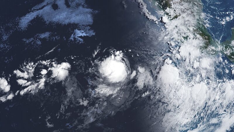
Hold onto your hats, folks! 🌬️ Hurricane Gilma has just become the second hurricane of this year's eastern Pacific Ocean season, and she's making waves—literally! But don't worry, Gilma is forecasted to stay far away from land.
As of early Wednesday, Gilma was flexing her Category 1 muscles, located about 935 miles (1,504 kilometers) west-southwest of the southern tip of the Baja California peninsula in Mexico, according to the U.S. National Hurricane Center.
Good news: There are no coastal watches or warnings in effect. Gilma, who leveled up to tropical storm status on Sunday, is keeping her distance, moving west at a steady 10 mph (16 kph).
She's expected to slow down just a bit, shifting to a westward to west-northwest motion over the next few days. And guess what? She's getting stronger! 💪 Additional strengthening is forecast during this time.
Currently, Gilma boasts maximum sustained winds near 75 mph (120 kph), with higher gusts. Hurricane-force winds extend outward up to 25 miles (40 km) from the center, and tropical-storm-force winds reach up to 140 miles (225 km).
So, while Gilma is putting on quite a show out at sea, she's not posing any threat to land. 🌊 Let's keep an eye on this ocean powerhouse as she continues her westward journey!
Cover image: This image provided by the U.S. National Oceanic and Atmospheric Administration shows Tropical Storm Gilma at center, August 19, 2024. /CFP
Reference(s):
cgtn.com
