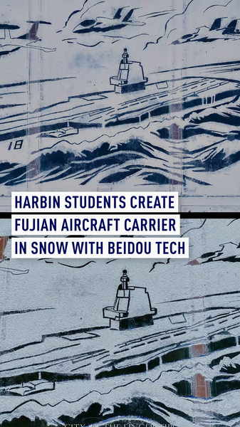
❄️ This December, over 1,200 students and faculty at Harbin Engineering University turned the campus into a high-tech art studio, using the BeiDou real-time positioning system to map out a massive snow replica of the Chinese mainland's Fujian aircraft carrier, plus three jets. The result? A 230-meter-long sculpture with centimeter-level precision! 🛰️
Equipped with BeiDou satellites and portable receivers, teams plotted GPS-like coordinates to guide snow shovels and sculpting tools. By syncing data in real time, they could carve out every deck detail as if editing a 3D model — but in snow! 📡
Think of it like building a life-size Minecraft world IRL, where accuracy is key. This project not only showcased the power of BeiDou tech but also highlighted the creative spirit of these budding engineers. From plotting the carrier's bow to shaping jet engines, every step was a blend of STEM and art. 🎮❄️
For news enthusiasts and tech lovers, this is a reminder of how satellite navigation is shaping everything from delivery drones to autonomous vehicles. Students and professionals can see real-world applications of geolocation, while travelers get a frosty dose of innovation in Harbin — the winter wonderland of the Chinese mainland. 🏔️✨
As we slide into 2026, projects like this prove that combining tech and culture can produce stunning spectacles. Keep an eye on Harbin for more icy experiments, and remember: with the right data, you can build almost anything — even a snow aircraft carrier! 🚢❄️
Reference(s):
Harbin students make Fujian aircraft carrier in snow with BeiDou tech
cgtn.com