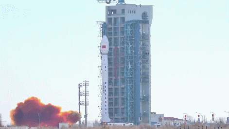
🚀 Earlier today, at 12:12 p.m., the Chinese mainland successfully lifted off its latest mapping satellite, Tianhui-7, from the Jiuquan Satellite Launch Center. The mission, carried out by a Long March-4B rocket, marks a thrilling moment for space fans and data geeks alike!
Developed by the China Academy of Space Technology, Tianhui-7 (meaning Sky Drawing) is set to revolutionize geographic mapping with high-resolution images. Its main tasks include national land resource surveys and a suite of scientific experiments designed to deepen our understanding of Earth.
The Long March-4B, a three-stage, liquid-propelled workhorse from the Shanghai Academy of Spaceflight Technology, can handle diverse payloads and orbit types. For this mission, it delivered up to 2.5 tonnes into a sun-synchronous orbit at 700 kilometers above Earth.
Fun fact: This launch is the final Long March-4 series mission for 2025, capping off a year of seven successful flights. Overall, it’s the 622nd flight mission of the Long March carrier rocket family—a true space marathon!
With Tianhui-7 now in orbit, data lovers and mapping pros around the world have reason to celebrate. Stay tuned for updates on its first snapshots!
Reference(s):
cgtn.com